Planning a pilgrimage to Omkareshwar Jyotirlinga but confused about which road to take or how far it really is? You are not alone. Every year, lakhs of devotees search for a reliable Omkareshwar Temple route map before starting their yatra.
Omkareshwar Temple is situated on the sacred Mandhata island in the Narmada River, in Khandwa district, Madhya Pradesh. It is one of the 12 Jyotirlinga temples of Lord Shiva and holds immense spiritual significance in Hinduism.
This guide gives you verified route maps, exact distances, en-route towns, and practical travel tips from Indore, Khandwa, Bhopal, Ujjain, and Maheshwar — so you can plan your Omkareshwar pilgrimage route with confidence.
⚡ Quick Overview
Nearest Airport: Devi Ahilyabai Holkar Airport, Indore (77–80 km)Nearest Railway Station: Omkareshwar Road Station, Mortakka (12 km from temple)Best Base City: IndoreFastest Route: Indore → NH-52 → OmkareshwarTravel Time from Indore: 2 to 2.5 hoursBest Travel Months: October to MarchMonsoon (July–Sep): Travel possible but may be congested near Narmada belt
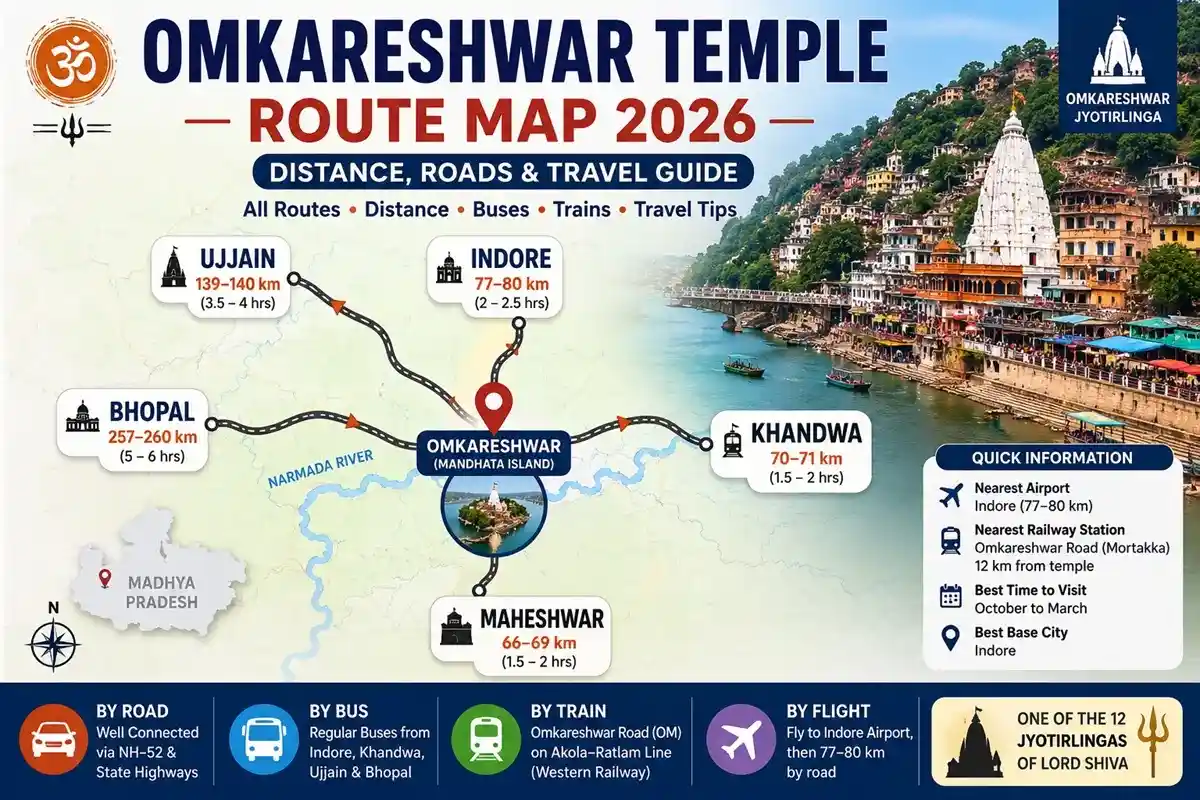
Omkareshwar Temple Route Map – Distance Overview
Here is a quick reference table for Omkareshwar road distance from major nearby cities:
| Starting City | Distance | Travel Time | Best Mode |
| Indore | ~77–80 km | 2 – 2.5 hrs | Cab / Bus via NH-52 |
| Khandwa | ~70–71 km | 1.5 – 2 hrs | Cab / Bus |
| Bhopal | ~257–260 km | 5 – 6 hrs | Cab / Train+Cab |
| Ujjain | ~139–140 km | 3.5 – 4 hrs | Cab / Bus |
| Maheshwar | ~66–69 km | 1.5 – 2 hrs | Cab |
Indore to Omkareshwar Route Map
The Indore to Omkareshwar distance is approximately 77 to 80 km by road via NH-52, making Indore the most convenient base for this Jyotirlinga darshan. Most pilgrims doing a same-day Omkareshwar trip from Indore prefer this route.
- Route: Indore → NH-52 (Indore–Khandwa Road) → Barwaha → Omkareshwar
- Key towns on the way: Simrol, Choral, Balwara, Barwaha
- You will cross the Narmada River before entering Mandhata island.
- Travel time: approximately 2 to 2.5 hours by cab or private vehicle.
- During Mahashivratri or Shravan Mondays, start by 6 AM to avoid traffic congestion.
Indore to Omkareshwar – Google Route Map
Khandwa to Omkareshwar Route Map
Khandwa is the district headquarters of the Khandwa district and is the closest major town to Omkareshwar. The road distance is approximately 70 to 71 km.
- Route: Khandwa → NH-52 → Sanawad–Omkareshwar Road → Omkareshwar
- En-route towns: Chhegaon Makhan, Sanawad, Barwaha
- Travel time: 1.5 to 2 hours by road.
- Frequent government and private buses operate from Khandwa bus stand.
Bhopal to Omkareshwar Route Map
Bhopal, the state capital of Madhya Pradesh, is approximately 257 to 260 km from Omkareshwar. It is a longer journey but the roads are well-maintained.
- Recommended route: Bhopal → Sehore → Ashta → Kannod → Omkareshwar
- Travel time by road: approximately 5 to 6 hours.
- Alternative: Take a train from Bhopal to Khandwa (major railhead), then a cab for the final 70 km stretch.
Ujjain to Omkareshwar Route Map
Ujjain is approximately 139 to 140 km from Omkareshwar. Many pilgrims combine Mahakaleshwar darshan in Ujjain with Omkareshwar on the same trip — a popular Jyotirlinga pilgrimage circuit in Madhya Pradesh.
- Best route: Ujjain → Dewas → Kannod → Sanawad → Omkareshwar
- Travel time: 3.5 to 4 hours by cab or private vehicle.
- Regular buses operate from Ujjain bus stand to Omkareshwar.
- Approximate bus fare: ₹230 to ₹250 (non-AC). Fares vary by operator and season.
Maheshwar to Omkareshwar Route Map
Maheshwar is one of the closest starting points to Omkareshwar at approximately 66 to 69 km. Many pilgrims visiting Maheshwar — a historic town on the Narmada — combine it with Omkareshwar darshan.
- Route: Maheshwar → Mandleshwar → Barwaha → Omkareshwar via MP SH-38
- Travel time: 1.5 to 2 hours by cab.
- The route runs along the Narmada riverbank and is scenic.
Omkareshwar Route Map by Different Transport Modes
By Road (Cab / Private Vehicle)
Road travel is the most flexible and popular option for Omkareshwar pilgrimage. NH-52 from Indore is the best-maintained route. Cabs are available from Indore, Khandwa, and Ujjain at standard outstation rates.
By Bus
Government MPRTC buses and private operators run regular services to Omkareshwar from Indore, Khandwa, Ujjain, and Bhopal. Non-AC bus fares from Indore start from approximately ₹120 to ₹165, though fares vary by operator and season. Book AC bus tickets in advance during peak season.
By Train
The nearest railway access point is Omkareshwar Road Station (station code: OM) at Mortakka, on the Akola–Ratlam rail line under Western Railway. The station is approximately 12 km from the temple. From the station, take a local auto-rickshaw or taxi. Khandwa Railway Station is the nearest major railhead at approximately 70 km from the temple. Check current train schedules on IRCTC before planning.
By Flight
No direct flight exists to Omkareshwar. The nearest airport is Devi Ahilyabai Holkar Airport, Indore (IATA: IDR), approximately 77 to 80 km from the temple. From the airport, hire a pre-booked cab for a direct transfer to Omkareshwar.
Suggested Tour:
Important Places Around Omkareshwar
When planning your Omkareshwar pilgrimage route, keep these key locations in mind:
| Place | Distance from Temple | Significance |
| Mamleshwar Temple | 0.5 km (across bridge) | Second Jyotirlinga on same island |
| Mandhata Island | At temple | Om-shaped island in Narmada |
| Mortakka (Railway Station) | 12 km | Nearest rail access point |
| Maheshwar | 66–69 km | Historic Narmada ghats & Ahilya Fort |
| Khandwa | 70–71 km | Nearest district town |
| Indore | 77–80 km | Nearest airport & major city |
| Ujjain | 139–140 km | Mahakaleshwar Jyotirlinga |
| Bhopal | 257–260 km | State capital, rail + road hub |
Best Time to Visit Omkareshwar
From a travel perspective, October to March is the most comfortable season for Omkareshwar darshan. The weather in central India is moderate during these months and the roads are clear.
- October to March: Best weather for darshan and island parikrama.
- Mahashivratri (February–March): Most auspicious time; extremely high footfall. Book accommodation and transport at least 2–3 weeks in advance.
- Shravan Mondays (July–August): Heavily visited despite the monsoon; expect congestion near the temple.
- July to September (Monsoon): Travel is possible, but heavy rainfall and river-level rise in the Narmada may affect the experience. Plan with extra buffer time.
Common Mistakes to Avoid
- Not planning the 12 km transfer from Omkareshwar Road Station (Mortakka) to the temple in advance.
- Travelling during Mahashivratri without hotel booking — accommodation runs out days before.
- Skipping Mamleshwar Temple, which is just across the bridge and equally sacred.
- Not carrying cash — ATMs in Omkareshwar town are limited; withdraw from Indore or Khandwa.
- Starting late from Indore — an early morning start (6–7 AM) ensures comfortable darshan and same-day return.
Pro Tips for Omkareshwar Yatra
- Start from Indore by 6 AM for a comfortable same-day darshan and return trip.
- Club Maheshwar (66–69 km) with Omkareshwar for a two-temple Narmada circuit in one day.
- Wear comfortable footwear — the island parikrama involves uneven stone steps.
- Prasadalaya near Mamleshwar Bridge offers subsidised langar; coupons at ₹10 available between 8:30–10:30 AM.
- Senior citizens and those with limited mobility should inquire about palkhi service at the ghats.
Our Route Recommendation
Based on our experience operating Omkareshwar pilgrimage tours for over 18 years, the Indore–NH-52–Omkareshwar route is the most reliable and comfortable option for most pilgrims.
If you are combining Ujjain (Mahakaleshwar) and Omkareshwar, we recommend: Ujjain → Dewas → Kannod → Omkareshwar. This route avoids city traffic and takes about 3.5 hours. For families and senior citizens, a private cab with a known driver is far better than relying on buses during peak season.
For pilgrims arriving by train, deboard at Omkareshwar Road (Mortakka) and arrange a local auto or taxi for the 12 km stretch. This saves 2–3 hours compared to going to Indore city first.
Conclusion
Omkareshwar Jyotirlinga is one of the most accessible sacred temples in India. Whether you follow the Omkareshwar pilgrimage route from Indore (77–80 km via NH-52), Khandwa (70–71 km), Ujjain (139–140 km), Bhopal (257–260 km), or Maheshwar (66–69 km), all roads are well-connected and manageable.
For budget pilgrims, MPRTC buses from Indore or Khandwa are the most practical. For comfort, a private cab is ideal — especially for senior citizens and families. Pilgrims arriving by train should plan the 12 km last leg from Omkareshwar Road Station in advance.
Plan your visit between October and March. For Mahashivratri, book at least 2–3 weeks early. For a fully planned, hassle-free Omkareshwar darshan package, contact Pilgrimage Tour India.
Frequently Asked Questions (FAQs)
Q1. What is the distance from Indore to Omkareshwar Temple?
The road distance from Indore to Omkareshwar is approximately 77 to 80 km via NH-52. Travel time is about 2 to 2.5 hours by cab or private vehicle under normal traffic.
Q2. What is the best route from Indore to Omkareshwar?
The best route is via NH-52 (Indore–Khandwa Road) passing through Simrol, Choral, Balwara, and Barwaha. This is the fastest and most recommended Omkareshwar road trip route from Indore.
Q3. Is Omkareshwar accessible by train?
Yes. The nearest railway station is Omkareshwar Road (station code: OM) at Mortakka, about 12 km from the temple on the Akola–Ratlam rail line. From the station, take a local auto or taxi.
Q4. What is the nearest railway station to Omkareshwar Temple?
Omkareshwar Road Station (Mortakka), station code OM, is the nearest rail access point — approximately 12 km from the temple. Khandwa Junction is the nearest major railhead at about 70 km.
Q5. Can Omkareshwar be visited in one day from Indore?
Yes. At 77–80 km, a same-day Omkareshwar trip from Indore is very practical. Start by 6–7 AM, complete darshan and parikrama, visit Mamleshwar Temple, and return by evening comfortably.
Q6. How far is Omkareshwar from Indore Airport?
The road distance from Devi Ahilyabai Holkar Airport, Indore to Omkareshwar is approximately 77 to 80 km. A pre-booked cab from the airport to the temple takes about 2 to 2.5 hours.
Q7. What is the best route from Ujjain to Omkareshwar?
The best route from Ujjain to Omkareshwar is via Dewas and Kannod, covering approximately 139 to 140 km in about 3.5 to 4 hours by road. Many pilgrims combine Mahakaleshwar and Omkareshwar on this Jyotirlinga circuit.
Q8. What is the Omkareshwar route map from Bhopal?
The recommended road route from Bhopal to Omkareshwar is: Bhopal → Sehore → Ashta → Kannod → Omkareshwar, covering approximately 257 to 260 km in about 5 to 6 hours.
Q9. How much walking is required at Omkareshwar?
The island parikrama (circumambulation) at Omkareshwar is approximately 7 km on foot along stone paths and ghats. Comfortable footwear is essential. Shorter darshan without the full parikrama is also possible.
Q10. Is VIP Darshan available at Omkareshwar Temple?
Special darshan passes are available at Omkareshwar Temple for a quicker entry. Availability and timings may change, especially during Mahashivratri and Shravan. Verify current details with the temple trust before visiting.
Q11. Can senior citizens visit Omkareshwar easily?
Yes, with some planning. The temple approach involves stairs and uneven paths near the ghats. Palkhi (palanquin) services are available for senior citizens at the ghats. A private cab is recommended over buses for comfort.
Q12. Which is better to visit first – Omkareshwar or Maheshwar?
If coming from Indore, visit Omkareshwar first and Maheshwar on the return — both are on the Narmada and roughly 66 to 69 km apart. This makes for a practical and spiritually rich one-day Narmada circuit.
Q13. What are Omkareshwar Temple timings?
Omkareshwar Temple is generally open from 5:00 AM to 9:30 PM. Timings may change during festivals and special occasions. Verify current timings with the temple trust or Pilgrimage Tour India before your visit.
Q14. What is the bus fare from Indore to Omkareshwar?
Non-AC bus fares from Indore to Omkareshwar typically start from approximately ₹120 to ₹165. AC bus fares are higher. Exact fares vary by operator and season — check current rates at Indore bus stand or online booking platforms.
Q15. What is the Omkareshwar road condition in 2026?
The NH-52 (Indore–Khandwa Road) to Omkareshwar is generally well-maintained and suitable for comfortable road travel. During monsoon months, some stretches near Barwaha and the Narmada belt may see slower traffic. Start early for best road conditions.


 Call
Call WhatsApp
 Enquiry