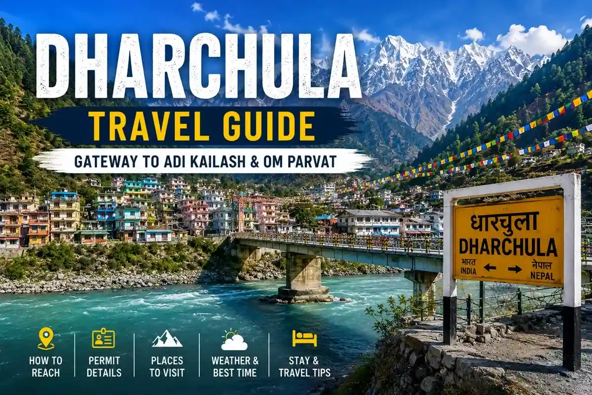
Dharchula is a Himalayan border town in Pithoragarh district, Uttarakhand, sitting on the Kali River that separates India from Nepal. It’s best known as the last well-equipped stop before the restricted routes to Adi Kailash and Om Parvat, and as a genuine twin town — its Nepali counterpart, Darchula, sits right across the water.
Quick Facts Box
| Detail | Information |
|---|---|
| Location | Pithoragarh district, Uttarakhand |
| Elevation | Approx. 940 metres (3,080 ft) |
| River | Kali (Mahakali) River — India-Nepal boundary |
| Twin town | Darchula, Nepal (footbridge crossing) |
| Population | 7,039 (2011 Census); likely higher today, no newer official count yet |
| Border security (Indian side) | Sashastra Seema Bal (SSB) |
| Nearest airports | Pantnagar (~317 km); Pithoragarh’s Naini Saini airstrip has limited seasonal flights |
| Permit office | SDM office, Dharchula (Inner Line Permit; process can change — verify before travel) |
What Is Dharchula?
Dharchula sits in a narrow valley with the Panchachuli range to its west, visible on exceptionally clear days from select viewpoints rather than guaranteed year-round. The Kali River splits the town from its Nepali twin, Darchula, and residents on both banks may cross the pedestrian footbridge without a passport, subject to current regulations.
For pilgrims, Dharchula is the last stop before permit-only territory toward Gunji, Nabi, Kutti, and Jolingkong in the Byans and Vyas valleys.


Etymology and History
Local tradition offers two explanations for the name: “Dhar” (peak) and “Chula” (a three-stone fire stove), tied to a legend of sage Vyasa cooking here on his way to Kailash; or “Darchyo” (a prayer flag) with the honorific “la.” Both are regional beliefs rather than settled historical fact.
Dharchula was historically a halting point on Trans-Himalayan trade routes linking Kumaon and Tibet, with barter trade in woollen “dan” carpets. The 1962 Indo-China war ended this trade, and the town’s economy shifted toward services and tourism. More recently, the Border Roads Organisation (BRO) completed the roughly 80-km Dharchula–Lipulekh stretch around 2020, cutting travel times toward Gunji and the Lipulekh Pass considerably.
Geography, Climate and Culture
| Season | Months | Approx. Day Temp | Conditions |
|---|---|---|---|
| Summer | April–June | 18°C–28°C | Pleasant, good for onward travel |
| Monsoon | July–September | 15°C–25°C | Heavy rain, landslide risk on the Pithoragarh road |
| Autumn | October–November | 10°C–20°C | Clear skies, cool |
| Winter | December–March | 4°C–15°C | Cold, occasional snow at higher points nearby |
Dharchula’s population blends Kumaoni, Rung (Shauka/Bhotiya), and Nepali communities. The Rung community speaks RungLo, alongside Hindi and Kumaoni, and marks festivals with folk songs and a traditional local brew called “sathani.” Nearby Jauljibi’s annual trade fair, at the Gori-Kali confluence, still reflects the region’s cross-border trading roots.
Permits, Border Rules and Restricted Areas
An Inner Line Permit from the Dharchula SDM office is mandatory for travel toward Gunji, Kutti, Nabi, or Kalapani; requirements can include medical fitness and identity verification, and the exact process has changed over time, so confirm current documentation before your trip. Foreign nationals are generally not permitted into this restricted zone, unlike the open Indian-Nepali footbridge crossing at Dharchula itself, which is secured by the SSB on the Indian side.
This general border region also borders the long-standing India-Nepal discussion over the Kalapani-Lipulekh-Limpiyadhura area further up the valley — a matter of official diplomacy rather than something that affects routine footbridge crossings at Dharchula.
Local Life Beyond the Guidebook Basics
A few details rarely covered elsewhere help round out the picture. Traditional Rung houses in and around Dharchula often use stone and timber construction suited to the region’s cold winters, and many families still maintain seasonal migration patterns tied to the Byans, Darma, and Chaudans valleys above town — a rhythm that predates organized tourism by generations. Local festivals follow a broadly agricultural and lunar calendar, with community gatherings featuring folk dance and song more prominent than large temple events. Photography around town is generally welcome, but travelers should ask before photographing border infrastructure or security personnel, and drone use near the border requires separate clearance that most casual visitors won’t have.
Things to Do in Dharchula
- Cross the Indo-Nepal suspension bridge over the Kali River — no passport needed for Indian and Nepali citizens.
- Visit Narayan Ashram, founded in 1936 near 2,700 metres; it has traditionally offered simple food and stay to travelers, though availability depends on the season and management.
- Look for the Panchachuli peaks from town viewpoints on clear days.
- Check for seasonal river activities on the Kali, such as rafting through local operators — availability varies and isn’t guaranteed year-round.
- Shop at Simalgair, Naya Bazar, or Purana Bazar for woollens and Kumaoni handicrafts.
- Use it as a base for treks toward Adi Kailash, Om Parvat, and the Darma and Chaudans valleys.
How to Reach Dharchula
| From | Approx. Distance | Typical Travel Time |
|---|---|---|
| Delhi | ~600 km | 15–18 hours by road |
| Pantnagar Airport | ~317 km | 9–10 hours |
| Tanakpur Railway Station | ~200–240 km | 7–8 hours |
| Pithoragarh | ~90–92 km | 3–4 hours |
Some travelers also fly into Dehradun for helicopter-linked packages, though this isn’t a standard route. Beyond Dharchula, the road to Gunji and Jolingkong is permit-restricted.
Best Time, Budget and Practical Basics
April–June and October–November bring the most stable weather; avoid the July–September monsoon due to landslides. Dharchula has the last reliable ATM and fuel pump before the restricted zone, so withdraw cash and fill your tank here — UPI works in town but shouldn’t be relied on further up. Mobile coverage (BSNL mainly, with patchy Jio/Airtel) weakens noticeably beyond Gunji. A Community Health Centre handles basic care, but serious cases are referred to Pithoragarh. Stay options are limited to KMVN guest houses and a few private lodges, so book ahead in peak season.
Safety Tips for Travelers
- Carry a valid government ID for the footbridge and local checkpoints.
- Withdraw sufficient cash — ATM access is unreliable past Dharchula.
- Pack basic medication; medical facilities thin out quickly beyond town.
- Check road status before the Pithoragarh–Dharchula stretch in monsoon months.
Key Takeaways
- Dharchula is a Himalayan border town on the Kali River, split between India and Nepal, in Pithoragarh district.
- It’s the main gateway and Inner Line Permit point for Adi Kailash and Om Parvat.
- Its history moves from Trans-Himalayan trade hub to modern pilgrimage gateway, reshaped by the 1962 war and later BRO road work.
- Several commonly repeated claims — guaranteed Panchachuli views, regular rafting, or unchanging permit rules — should be treated as variable, not fixed.
- Dharchula is the last reliable stop for cash, fuel, and network before the restricted high-altitude route.
In short, Dharchula isn’t just a stopover — it’s a genuine frontier town worth understanding on its own terms before heading onward toward Adi Kailash.
FAQs
Q1. Is Dharchula worth visiting on its own?
Yes — the suspension bridge, Kali riverside, and local bazaars make it worthwhile even without trekking further.
Q2. Can foreigners visit Dharchula?
Dharchula town itself is generally accessible, but the restricted zone beyond it toward Adi Kailash is closed to foreign nationals.
Q3. Is a permit required to visit Dharchula itself?
No, but an Inner Line Permit from the SDM office is required to travel beyond it.
Q4. How do I reach Dharchula from Delhi?
By road, it’s roughly 600 km, typically taking 15–18 hours via Pithoragarh.
Q5. Is mobile network available in Dharchula?
BSNL generally works; Jio and Airtel coverage is patchy and weakens further up the route.
Q6. Is Aadhaar enough for the permit process?
Aadhaar is commonly used, but requirements can include medical fitness and other verification — confirm current rules before travel.
Q7. Where can I withdraw cash or get fuel?
Dharchula has the last reliable ATM and fuel pump before the restricted zone.
Q8. What is the best time to visit Dharchula?
April–June and October–November, avoiding the July–September monsoon landslide risk.
Q9. Which force secures the India-Nepal border here?
The Sashastra Seema Bal (SSB), alongside local police.
Q10. Can I stay overnight in Dharchula?
Yes, KMVN guest houses and private lodges are available; booking ahead is wise in peak season.
Q11. Does UPI work in Dharchula?
Yes, in town, but don’t rely on digital payments beyond this point.
Q12. Is river rafting available in Dharchula?
Seasonal rafting may be offered by local operators, but it isn’t a guaranteed, year-round activity.
Q13. What language is spoken in Dharchula?
RungLo is the traditional local language, alongside Hindi and Kumaoni.
Q14. How far is Dharchula from Adi Kailash?
The onward route through Gunji to Jolingkong covers roughly 100–120 km, requiring an Inner Line Permit.


 Call
Call WhatsApp
 Enquiry