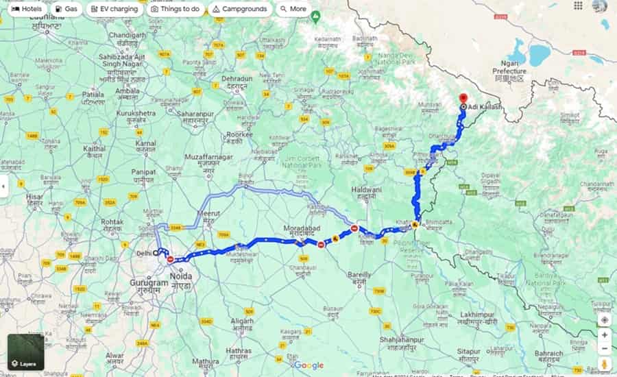
Nestled at a great elevation in the Kumaon Himalayas, Adi Kailash is counted among the most sacred pilgrimage sites in Hinduism. Also known as Chota Kailash, this sky-touching peak is believed to be a counterpart of Mount Kailash in Tibet. Because of its mythology, deep spiritual significance, and the physical resemblance to the great Kailash, this Shiva pilgrimage holds a special place for devoted pilgrims.
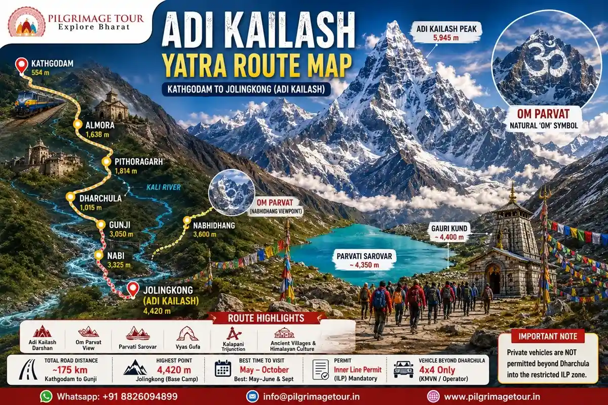
The route to Adi Kailash passes through the Pithoragarh district of Uttarakhand, following the valley of the Kali river through some of the most remote and beautiful terrain in India. Along the way, you see the sacred Parvati Sarovar lake and Gauri Kund at Jolingkong — both considered highly sacred.
This guide covers every section of the Adi Kailash Yatra route map, with accurate distances, altitudes, travel times, and highlights at each stop. Whether you are planning an 8-day yatra from Kathgodam or a 2-day helicopter tour from Pithoragarh, understanding the full route helps you prepare better and avoid common mistakes.
Adi Kailash Route 2026 — At a Glance
Adi Kailash Route — Complete Distance & Altitude Chart
Here is the complete Adi Kailash route with distances and altitudes for every key segment:
| Segment | Distance | Travel Time | Altitude (Destination) | Road Type |
|---|---|---|---|---|
| Kathgodam → Pithoragarh | ~175 km | 5–6 hours | 1,814 m (Pithoragarh) | State highway, good road |
| Pithoragarh → Dharchula | ~91 km | 3 hours | 1,015 m (Dharchula) | Descends to Kali valley |
| Dharchula → Tawaghat | ~18 km | 45 min | 895 m (Tawaghat) | Mountain road, narrow |
| Tawaghat → Budhi | ~39 km | 2 hours | 1,900 m (Budhi) | Rough, rocky road |
| Budhi → Nabi/Gunji | ~35 km | 2 hours | 3,050 m (Gunji) | 4×4 only, restricted zone |
| Gunji → Nabhidhang (Om Parvat) | ~16 km | 45 min by road | 3,600 m (Nabhidhang) | Motorable, viewpoint stop |
| Gunji → Nabi → Jolingkong | ~20-25 km | 2 days trek or 1.5 hr by 4×4 | 4,420 m (Jolingkong) | Partly motorable, partly trek |
| Jolingkong → Adi Kailash viewpoint | Short walk | 15–20 min | ~3,750 m (viewpoint) | On foot only |
| Return: Dharchula → Didihat/Chaukori | ~100 km | 3–4 hours | 1,900 m | State highway |
| Chaukori/Didihat → Kathgodam | ~175 km | 5–6 hours | 554 m (Kathgodam) | Good state highway |
| Important — 2026 Vehicle Restriction: Private vehicles are NOT permitted beyond Dharchula into the restricted ILP zone. Travel from Dharchula to Gunji and beyond is only by KMVN-operated vehicles or tour-operator-arranged 4×4 jeeps. Confirm your operator has the necessary permits for this zone before departure. |
Step-by-Step Route Guide — Kathgodam to Jolingkong
Making the journey to Adi Kailash is not only a religious act — it is a chance to experience raw mountain nature, ancient village culture, and a deep sense of inner stillness. Below is each key section of the route with highlights, distances, altitudes, and practical tips.
Kathgodam to Pithoragarh
| Detail | Information |
|---|---|
| Distance | ~175 km by road |
| Travel Time | 5–6 hours |
| Altitude at Pithoragarh | 1,814 m (5,951 ft) |
| Route | Kathgodam → Bhimtal → Almora → Bageshwar → Pithoragarh |
Kathgodam Railway Station is the main entry point for the Adi Kailash Yatra. It is the last railhead before the Kumaon hills begin and is well-connected to Delhi, Lucknow, and other major cities. From Kathgodam, the road to Pithoragarh passes through Bhimtal, Almora, and Bageshwar — a beautiful drive through pine forests, terraced fields, and Kumaon hill towns.
The drive takes 5–6 hours. The road is in good condition for most of the route. Pithoragarh, at 1,814 m, is surrounded by peaks and is known as the ‘Mini Kashmir’ of Uttarakhand. It is also the jump-off point for the helicopter Adi Kailash tour.
Major Highlights
- Kainchi Dham — the famous ashram of Neem Karoli Baba, located between Bhimtal and Almora. A peaceful and spiritually charged stop.
- Chitai Temple — the well-known temple of Golu Devta, the justice deity of Kumaon, near Almora.
- Jageshwar Dham — a cluster of 124 ancient stone temples in a deodar forest near Almora, dedicated to Lord Shiva. One of the most important archaeological temple sites in Uttarakhand.
Keep some light snacks and water for this 5–6 hour journey. There are dhabas along the route but carrying your own provisions is safer.
Pithoragarh to Dharchula
| Detail | Information |
|---|---|
| Distance | ~91 km |
| Travel Time | ~3 hours |
| Altitude at Dharchula | 1,015 m (3,330 ft) |
| Route | Pithoragarh → Askot → Dharchula |
From Pithoragarh, the road heads east and gradually descends into the Kali River valley to reach Dharchula. Dharchula is a border town on the banks of the Kali river, with Nepal’s town of Darchula visible across the water on the opposite bank.
Dharchula is the last major town before the restricted zone begins. This is where you must have your Inner Line Permit (ILP) ready for checking. Stock up on supplies, medicines, and cash here — there are no functioning ATMs beyond this point.
Major Highlights
- Confluence of the Gori and Kali rivers — visible just before Dharchula.
- Jwaleshwar Temple — a sacred Shiva shrine on the outskirts of Dharchula.
- Narayan Ashram — a notable spiritual institution situated between Tawaghat and Dharchula, in a forest setting.
| Practical Note: Withdraw sufficient cash at Dharchula. Carry medicines, any prescription drugs, and extra fuel if travelling by 4×4. Mobile network coverage is available until Dharchula — it stops working as you go further into the restricted zone. A Jio or BSNL SIM gives the best connectivity in this region. |
Dharchula to Gunji / Nabi
| Detail | Information |
|---|---|
| Distance | ~80 km (Dharchula to Gunji) |
| Travel Time | 3–4 hours by 4×4 |
| Altitude at Gunji | 3,050–3,325 m (10,000–10,909 ft) |
| Route | Dharchula → Tawaghat → Malpa → Budhi → Chiyalekh → Gunji |
| Vehicle | 4×4 only — private vehicles not permitted in restricted zone |
This is where the real mountain journey begins. From Dharchula, the road goes up steeply through deep gorges, cliffs, and remote villages before reaching the high-altitude hamlets of Gunji and Nabi. The landscape changes dramatically — forested lower slopes give way to open rocky terrain and high Himalayan views.
The route passes through several small villages including Tawaghat, Pangla, Lakhanpur, Malpa, Budhi, and Chiyalekh before reaching Gunji. The road is rough and narrow in sections, especially between Tawaghat and Budhi. Only KMVN or tour-operator 4×4 vehicles are allowed in this restricted zone.
Major Highlights
- Malpa — a village with a sobering history. In 1998, a massive landslide here killed over 255 people, including Kailash Mansarovar Yatris and local residents. A memorial stands here.
- Chiyalekh meadows — high-altitude grasslands with views of Mount Api, Nanjing Parvat, and the Nepal Himalayan range.
- Views of Mount Api (7,132 m), Nanjing Parvat, and the Annapurna range (on clear days).
- Gunji village — the main base camp for the Adi Kailash and Om Parvat circuit. Small homestays and a KMVN rest house are available here.
Gunji – Kalapani – Nabhidhang – Nabi (Om Parvat Route)
| Detail | Information |
|---|---|
| Gunji to Nabhidhang | ~20 km by road |
| Travel Time | ~45 minutes |
| Altitude at Nabhidhang | ~3,600 m (11,811 ft) |
| Gunji to Om Parvat viewpoint (total from Dharchula) | ~110 km from Dharchula |
From Gunji, the route for Om Parvat heads northwest through Kalapani and up to Nabhidhang — the viewpoint from where Om Parvat is clearly visible. Kalapani is a historically and strategically important location near the source of the Kali river, very close to the India-Nepal-Tibet trijunction.
Nabhidhang is the best viewpoint for Om Parvat. Here, the sacred mountain displays a natural ‘OM’ (ॐ) symbol formed by snow settling in the rock crevices on its face. This is one of the rarest and most revered natural formations anywhere in the Himalayas — and seeing it clearly on a clean morning is an experience pilgrims remember for life.
Major Highlights
- Om Parvat — the mountain with the naturally formed OM symbol in snow. Clearly visible from Nabhidhang. Best viewed early morning (7 AM–11 AM).
- Ganesh Parvat and Naag Parvat — visible from the Nabhidhang viewpoint area.
- Vyas Gufa — a sacred cave near Gunji-Nabi area where sage Veda Vyasa is said to have meditated.
- Kalapani Kali Temple — a small but important Kali temple at the Kalapani confluence point.
- Old Lipulekh Pass area — the historical trans-Himalayan trade route at the India-Nepal-Tibet trijunction.
Nabi to Jolingkong — Adi Kailash Viewpoint
| Detail | Information |
|---|---|
| Distance | ~30 km from Gunji/Nabi |
| Travel Time | 2 days trek OR ~1.5 hrs by 4×4 (road conditions permitting) |
| Altitude at Jolingkong | ~4,420 m (14,500 ft) — base camp |
| Adi Kailash peak altitude | 5,945 m (19,505 ft) |
| Via | Nabi → Kutti village → Jolingkong |
From Nabi, the route continues to Jolingkong — the meadow and viewpoint area at the base of Adi Kailash. A short walk from where vehicles stop brings you to the full view of the sacred peak. This moment is what pilgrims travel days to experience.
At Jolingkong, the Shiva-Parvati temple stands beside the sacred Parvati Sarovar lake — a glacial lake at the base of the mountain. This lake is considered deeply holy, dedicated to Goddess Parvati. Just above it is Gauri Kund — a smaller sacred pool. The area of Jolingkong sits in a high-altitude meadow ringed by Himalayan peaks, with Adi Kailash dominating the skyline.
Major Highlights
- Adi Kailash (Chota Kailash) — the sacred peak that mirrors Mount Kailash in Tibet. Full view from the Jolingkong meadow.
- Parvati Mukut — the ridge formation above and around Adi Kailash, shaped like a crown.
- Parvati Sarovar — the glacial lake at the base of Adi Kailash, sacred to Goddess Parvati. Water here is considered holy.
- Gauri Kund — a small sacred pool above Parvati Sarovar.
- Kutti Village — an ancient village on the route with history connected to the Mahabharata era. Kunti Killa nearby is associated with the Pandava queen Kunti.
- Pandav Parvat — the ridge believed to be associated with the Pandavas’ final Himalayan journey route.
Return Route — Nabi / Gunji to Dharchula
| Detail | Information |
|---|---|
| Distance | ~80 km (Gunji to Dharchula) |
| Travel Time | 3–4 hours |
| Route | Gunji → Budhi → Malpa → Tawaghat → Dharchula |
The return from Gunji to Dharchula follows the same road in reverse. Most itineraries include a stop at Nabhidhang on the return for a second darshan of Om Parvat if the visit was cloud-covered on Day 3. From Dharchula, you either head directly back toward Pithoragarh/Kathgodam, or take the scenic detour via Didihat and Chaukori.
Major Highlights on Return
- Parvati Temple at Tawaghat — a brief prayer stop on the way down.
- Kali temple at Tawaghat area — worth a quick visit.
- Chaukori viewpoint — a hilltop rest point with panoramic views of the Nanda Devi range, Panchachuli peaks, and Nandakot. A recommended overnight stop for those who want a quieter, scenic end to the Yatra.
Dharchula to Kathgodam (Return)
| Detail | Information |
|---|---|
| Distance | ~270 km (Dharchula to Kathgodam, via Pithoragarh) |
| Travel Time | 7–8 hours |
| Scenic Option | Dharchula → Didihat → Chaukori → Almora → Kathgodam (adds Chaukori viewpoint) |
The return drive from Dharchula to Kathgodam covers the same landscapes as the onward journey — in reverse. Most pilgrims prefer the Didihat and Chaukori route on the return for a different perspective and a final mountain panorama. You cross the same Kali and Saryu river valleys, returning to the plains through Almora and Bhimtal.
Complete Adi Kailash Yatra Route — Circuit Overview
The traditional Adi Kailash and Om Parvat circuit follows this full sequence:
| Day | Route | Key Activity | Night Stay |
|---|---|---|---|
| Day 1 | Kathgodam → Pithoragarh | En-route stops at Kainchi Dham, Chitai, Jageshwar | Pithoragarh |
| Day 2 | Pithoragarh → Dharchula | Jwaleshwar Temple, Narayan Ashram, ILP check | Dharchula |
| Day 3 | Dharchula → Gunji | Mountain gorge drive, Malpa, Chiyalekh meadows | Gunji |
| Day 4 | Gunji → Jolingkong → Gunji | Adi Kailash darshan, Parvati Sarovar, Gauri Kund | Gunji |
| Day 5 | Gunji → Nabhidhang → Nabi | Om Parvat darshan, Kalapani, Vyas Gufa, Lipulekh area | Nabi/Gunji |
| Day 6 | Nabi/Gunji → Dharchula | Return descent, Parvati Temple, Kali Temple stops | Dharchula |
| Day 7 | Dharchula → Chaukori/Didihat | Scenic detour, Panchachuli view, rest | Chaukori |
| Day 8 | Chaukori → Kathgodam | Return via Almora, Bhimtal | Departure |
Frequently Asked Questions (FAQs)
Q1. When is the best time to visit Adi Kailash?
May to October is the open season for Adi Kailash. June and September offer the best weather — clear skies, manageable temperatures, and good road conditions. July and August bring monsoon rains and an increased risk of landslides on the Dharchula–Gunji road. The route is closed from November to April due to heavy snowfall.
Q2. Are special permits needed for Adi Kailash Yatra?
Yes. The entire area beyond Dharchula falls within the Inner Line Permit (ILP) zone — a restricted border area near the India-Tibet-Nepal trijunction. Indian nationals must obtain an ILP from the SDM Office in Dharchula or through their tour operator. Foreign nationals need a Protected Area Permit (PAP) arranged through MEA-authorized operators — apply at least 60 days in advance.
Q3. Can people of all ages complete the Adi Kailash Yatra?
Most of the route is now motorable, but the high altitude — Gunji sits at over 3,300 m and Jolingkong at 4,420 m — is physically demanding. People with good fitness and no major heart or lung problems can manage this journey. For senior citizens or those with health conditions, the 4-day helicopter tour from Pithoragarh covers the same sites without any trekking. Consulting a doctor before travel is strongly recommended for anyone above 60 years.
Q4. What accommodation and food options are available en route?
Pithoragarh and Dharchula have proper hotels and guesthouses. Beyond Dharchula, basic accommodation is available at Gunji and Nabi in KMVN rest houses and local homestays. The food is simple home-cooked Kumaoni meals — dal, rice, roti, and sabzi. On organized tours, all meals are typically included. Do not expect restaurant-style food beyond Dharchula.
Q5. Is it possible to see both Adi Kailash and Om Parvat in one trip?
Yes — and most Adi Kailash Yatra itineraries cover both together. Adi Kailash (Jolingkong viewpoint) and Om Parvat (Nabhidhang viewpoint) are both reached from the Gunji base. The standard 8-day itinerary from Kathgodam includes separate days for each. The 4-day helicopter tour from Pithoragarh also covers both in the same circuit.
Q6. What is the altitude of the Adi Kailash viewpoint at Jolingkong?
The Jolingkong meadow — where you get the full view of Adi Kailash and where the Shiva-Parvati temple and Parvati Sarovar are located — sits at approximately 4,420 m (14,500 ft). The Adi Kailash peak itself rises to 5,945 m (19,505 ft). The viewpoint is well below the peak, making it accessible without mountaineering equipment.
Q7. How far is Gunji from Dharchula?
Gunji is approximately 80 km from Dharchula by road. The journey takes 3–4 hours by 4×4 vehicle through mountain roads, gorges, and the restricted border zone. Private vehicles are not permitted — only KMVN or tour-operator-arranged vehicles can travel this stretch.
Q8. How far is it from Kathgodam to Pithoragarh?
Kathgodam to Pithoragarh is approximately 175 km by road and takes 5–6 hours. The route passes through Bhimtal, Almora, and Bageshwar. Key stops on the way include Kainchi Dham (Neem Karoli Baba ashram), Chitai Golu Devta temple, and Jageshwar Dham.
Q9. Can I do the Adi Kailash Yatra without trekking?
Yes. Most of the route is now motorable up to Jolingkong — with only a short 15–20 minute walk on flat ground at the viewpoint itself. For those who cannot do even this, the helicopter package from Pithoragarh is the most comfortable option. ATV rides are also available on some sections of the Gunji–Jolingkong stretch through tour operators.
Q10. What is the total trekking distance for Adi Kailash from Gunji?
The Gunji to Jolingkong route is approximately 30 km one way. When the road is accessible by 4×4, vehicles can cover most of this distance with only a short 15–20 minute walk at Jolingkong. If trekking by foot (as some pilgrims prefer), the full Gunji–Jolingkong one-way trek takes 2 days. The round trip (including Om Parvat route via Nabhidhang) covers approximately 60 km total.


 Call
Call WhatsApp
 Enquiry